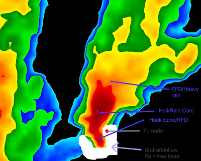
 Forgive the crudeness, but the white horseshoe looking draw-in is the updraft base/rain free base. I have also pointed out the area most likly to form a tornado. And as you can see, it is pretty much on a coupling between the updraft and RFD. Of course all storms are different but this will give you some idea as to the general structure.
 Now here I have marked with common weather symbols (i.e. cold front, warm front) the interactions taking place. Cold dry, or cold wet, air flowing out from the FFD region scouring up juice (warm moist air) into the storm. You can see too the pure warm air here being driven into the heart of the supercell, by the warm front symbol. In most cases supercells make there own mini weather systems. You can see also the RFD gust front here on the back side. The two cold front symbols are where the storm has generated cold pools that run out ahead of the main storm, called gust fronts. These areas are the likely place to find shelf clouds. The main FFD pseudo-front is also the place to find inflow cloud phenomena, e.g. a beaver tail and the like.
Not all supercells are the same! Some work intirely on drier air. Due to adiabatic processes, and complex thermodynamics, I will not get into that right now. But again some also ingest warm very moist air then spit out very cold wet air. Some are exceptionally windy, with gusts near 100 mph, and some have almost no wind at all. It also has to do with what phase the storm is in. Storm phases include, intiation, growing, mature, and dying. Some supercells manage to kind of recycle themselves. They are generally called cyclic supercells. What happens is when a storm cuts itself off of warm moist air, usually the RFD wrapping all the way around part of the updraft base, disrupting good structure. It will redevelop a replacment further east, but still connected to the orignal. And finally taking its place. Thats were those rain wrapped tornadoes come in. Meaning the storm produced a tornado but cut itself off, thereby hiding the tornado in a sheath of rain. Then a new tornado develops out of the new circulation.


No comments:
Post a Comment